
RFMapper ACMA Spectrum Mapping
An Australian spectrum licensing map — ACMA apparatus and area-wide licences, availability and expiry on one interactive HCIS map, refreshed from the register.
Overview
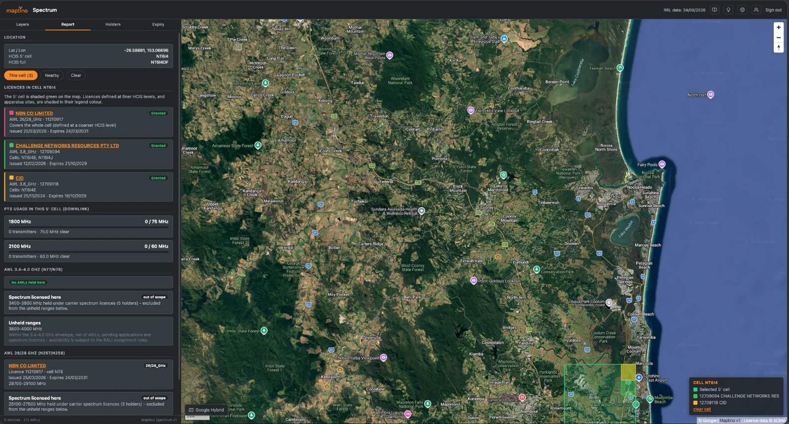
Maptino Spectrum is an ACMA licence map — the ACMA licence register turned into something you can plan with, with site lookup built in. The register is downloaded and reloaded automatically every morning, so the map always reflects the current licensing picture. The 1800 MHz and 2100 MHz layers colour every HCIS grid block by how much of the band is assigned to PTS apparatus, with a dot on every transmitter site. The AWL layers show every area-wide licence — granted and pending — in the 3.4–4.0 GHz and 26/28 GHz bands, drawn on the same hierarchical cell grid ACMA licenses against, down to the 20 second mmWave cells.
Click anywhere and the report answers the planning questions directly: which licences sit in that 5 minute cell, which frequency ranges are unheld once AWLs, pending applications and carrier spectrum licences are accounted for, and how far away the nearest apparatus assignments are. Click any licence to light up everything it covers; search any holder to see their entire footprint; set your own expiry warning window and watch renewals coming.
Capabilities
- Daily register sync. The full ACMA RRL extract downloaded and reloaded automatically each morning, with run history and integrity logging.
- HCIS spectrum map. PTS apparatus occupancy per grid cell at every level of the Australian spectrum map grid, from 3 degree blocks to 5 minute cells.
- AWL coverage. Granted and pending area-wide licences in the 3.4–4.0 GHz (n77/n78) and 26/28 GHz (n257/n258) bands, including the extended fine-grid mmWave cells.
- Point report. Licences in the clicked cell, unheld frequency ranges net of AWLs, applications and spectrum licences, and distance to the nearest apparatus assignments per band.
- Licence highlight. Click any licence to shade every cell and site it covers, anywhere in the country.
- Holder view. Search a licence holder and overlay their entire PTS and AWL footprint with expiry dates.
- Expiry tracking. Licences expiring within a user-set window, plus already-expired licences and how long ago they lapsed.
- Maptino platform. Shared sign-in, theming, audit logging and admin tooling across the Maptino family.
Under the hood
The HCIS geometry is computed, not traced — the converter implements the Australian spectrum map grid definition exactly, validated against 129,000 register site records to a 99.85% cell match. Availability is honest: pending applications block ranges the way first-in-time allocation treats them, and carrier spectrum licences are netted out of “unheld” even though they sit outside the tool’s scope.
Coming next
- Radio propagation modelling. Predicted coverage from real site, antenna and power data in the register, so a licence area becomes a realistic service footprint rather than a grid cell.
- Licence cost estimation. Potential ACMA licence costs derived from the propagation models, priced against the ACMA fee and spectrum-tax schedules, with what-if comparisons between candidate sites and bands.
Licence data from the Register of Radiocommunications Licences, © Commonwealth of Australia (ACMA), reproduced under the terms accompanying the RRL data download. Grid per the ACMA Australian spectrum map grid 2012. Basemaps © OpenStreetMap contributors, CARTO, Google and Esri under their own terms. Built on MapLibre GL JS (BSD-3-Clause).
RFMapper Drive Planner — Tablet Edition
Plan the drive test, drive it, and survey the buildings at either end — OpenStreetMap route plans to KML/CSV export.
RFMapper Desktop Analysis
Import survey logs, split by carrier, map coverage, find drop-out zones and generate the client report.
Want a demo, a licence, or a survey done?
One email covers all of it — tell us the tool or the job, and the region.